Workshop Timings: 15:00 to 18:00 (BST), 16:00 to 19:00 (CEST)
The CATRINE project will host an online workshop to discuss a new TransCom model intercomparison protocol focusing on high resolution and the transport of CO2 from fossil fuel emissions.
Registration is open to the CATRINE project participants, the TransCom community plus invited guests. Registration will be moderated by the event organisers.
Background and motivation:
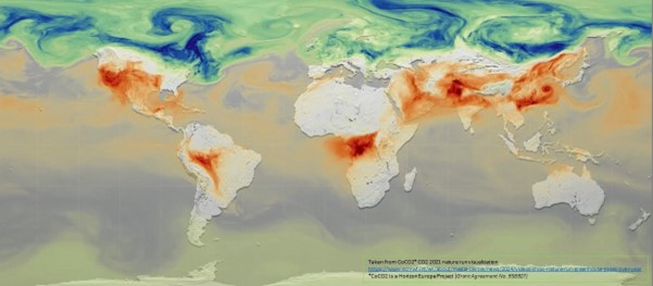
Monitoring the greenhouse gases CO2 and CH4 from space has made great strides over the past decade, in particular in terms of imaging capability. Existing instruments for CO2 include NASA's Orbiting Carbon Observatory-2 (OCO-2) with continuous sampling of cloud-free regions along the orbital path at a resolution of 3 km2, and NASA's OCO-3 which introduced the possibility of performing successive side-by-side scans of small areas (∼80 × 80 km2). For CH4, the TROPOMI instrument on board Copernicus Sentinel-5P provides near-daily surface coverage of cloud-free regions at a spatial resolution of up to 38.5 km2. In addition, retrieval capabilities at higher spatial resolution are emerging, for instance from Copernicus Sentinel-2 or from Greenhouse Gases Satellite (GHGSat). In the near future, the Copernicus CO2 Monitoring Mission (CO2M) will extend the imaging capability of CO2 to a level comparable to the existing one for CH4 from TROPOMI. This new wealth of CO2 and CH4 satellite retrievals pushes the application of such satellite data towards the inference of anthropogenic emissions and absorptions, with target spatial scales much finer than the traditional zonal or subcontinental scales of global atmospheric inversions. In this regard, the current generation of global atmospheric transport models that operate primarily at resolutions coarser than one degree, risks obsolescence because most models cannot exploit the higher resolution information in which most of the anthropogenic signals reside.
With this new protocol, we aim at stimulating high-resolution tracer transport modelling by setting-up a dedicated intercomparison exercise. By “high-resolution”, we first mean the equivalent of a grid spacing of 100 km in the horizontal, or a minimum of 51,000 horizontal grid points (about 1 degree × 1 degree resolution in the Tropics) to pave the world. On the vertical, we put a simple lower limit of 50 layers between the surface and the top of the atmosphere, assuming that it implies sufficient refinement of the planetary boundary layer and around the tropopause for constructive intercomparison. Indeed, the model vertical profiles will be particularly looked at in this exercise. We expect that their evaluation for several tracers using observed profiles from tall towers, aircraft and AirCore soundings will shed some light into the current discrepancies of atmospheric inversions that assimilate column retrievals or air-sample measurements.
Simulated tracers will be compared with each other, as will vertically integrated mass fluxes for total column. The reference observations will be diverse: ground-based or satellite tracer retrievals, air-sample measurements, as well as meteorological observations. We will define metrics to score the model performance. We will investigate how model configuration, like the vertical resolution, influences the model skill. The diagnostics will be applied to all tracers on weekly to monthly timescales, focusing on the impact of transport errors on the seasonal cycle at various layers and the total column. The correlation between the errors in the different layers with the error in the total column will support the attribution of the transport error. The high-resolution simulation database will be the first of this sort and may serve various applications beyond the planned model evaluation, from, e.g., model uncertainty quantification to AI training.
This initiative originates from the European project Carbon Atmospheric Tracer Research to Improve Numerics and Evaluation (CATRINE), which funds the coordination of the intercomparison, as well as some contributors, but it is hoped that other partners in the world will join the momentum and contribute to the study with their respective model and expertise.
The meeting will include half a day of presentations and discussions of this new protocol to get input from the TransCom community.
The CATRINE project is funded by the European Union, Grant Agreement 101135000.